Wednesday, May 3, 2017

Backpacking trip in Kalon Song Mao Nature Reserve

Last weekend, Lyriel and I and a couple friends (David and Roxanne) explored an area about 6 hours outside of Ho Chi Minh. There is some information floating around the internet about this area, but none in English that I know of. So I thought I'd share a trip report and the basic info others would need to go check it out. Enjoy! - Marshall

Overview


In between Da Lat and Mui Ne, there is a big chunk of mountainous land with very little development. On Google Maps it is called "Kalon Song Mao Nature Reserve." There are no roads connecting the southern part of the reserve (in Binh Thuan Province) to the northern part (in Lam Dong Province). But there are several trails which were probably built for logging originally. The trails stick to ridge lines, which have been cleared of trees and allowed to grow in with grass, leaving incredible views along most of the way. Fortunately, the loggers did not venture from from the ridge lines (probably due to extremely steep slopes), so most of the jungle is intact.
The most popular hiking option is one-way, which requires arranging transportation to the northern or southern trailhead and a pick up at the other end. Both ends are pretty remote and it is a 3+ hour drive between them. Our original plan was to leave our car in the south and arrange transport to the north, but I'm glad we ditched this in favor of a simple out-and-back starting from the south. We hiked 23.5km one way, so 47km total.

Getting there

We left Ho Chi Minh after work on Friday, and after a dinner stop, pulled over near Mui Ne about 10pm to camp on the beach. Lyriel's backpack was stolen from right next to her while we slept. The next day day we bought a new backpack and drove ~2 hours to our starting point at the base of a dam. The road getting there was mostly paved and any car will do. The first few kilometers of the hike is on a dirt road which I would not recommend driving unless you have a tank, but would be fine for scooters if you want to save time.

The road north of Mui Ne is in great shape and goes through huge dunes
Heading north towards the dam & starting point
Road quality is not great but you'll survive

You'll pass this reservoir on your way to a second reservoir where the trail starts

The trail, part I: flats

The first 9km are flat and easy*. You start on a very exposed dirt road, then turn left onto a motorbike path which takes you through forest with light underbrush. There are black boulders scattered around the forest floor, some of which might be geodes (I found a small broken one with partially formed crystals inside). They contrast with the neon green, Dr-Seuss-inspired vegetation. Look out for millions of caterpillars which hover above the trail and drop directly into your ears when you walk by. There are also cicadas here - the two-inch long flying bugs which make outrageously loud noises constantly for no reason. I've noticed there don't seem to be many mammals left in Vietnam, but they sure have a lot of bugs. Yum!
We crossed many dry stream beds and one flowing stream. I found out later that one of the "dry" ones was the same as the "wet" one, and the wet part was upstream... nature is wack. Anyway, this was one of only two places we found water on the whole trip. The next chance to fill up is 14.5 km and 1,000 meters of sun-baked, 90-degree (F) climbing later. Chug a lug! Bring lots of water containers.
This lower portion was the most difficult for navigation. The trails are very well defined, there are just too many of them weaving around the forest floor and splitting off. It's tough to spot surrounding peaks through the canopy, so you will probably rely on GPS here (see my KMZ download at end of this post). Several trails converge at the water source, and from that point on you will stay on the obvious and deeply rutted main trail up to the peaks.
*There is one .5km section with sustained 20% slope, but you'll forget about that later in the trip.
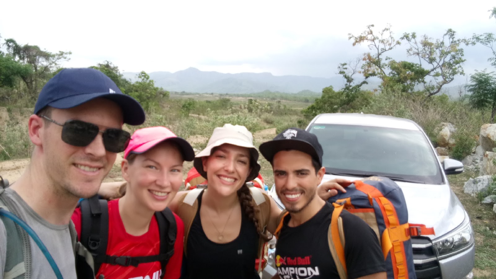
Me, Lyriel, Roxanne and David at the start of the hike

Big old trees along the starting dirt road

Most of the flat section looks like this
If we had not found this stream, it would have been a short trip

The trail, part II: climbing

The pleasant hike came to an abrupt halt as we started climbing the first big hill. It was getting dark and starting to thunderstorm, so we charged up the 800m, sustained 14% grade hill just in time to get poured on as we set up tents at the top. Then we realized our lighter was in Lyriel's stolen bag, ate cold couscous, and got attacked by bees for 14 consecutive hours. But the view the next morning was fantastic!

View from Peak #1. The previous night, we were pleasantly surprised as we were not hit by lightning and our tent floor turned into a luxurious water bed. If the floor's a-sloshin', don't come a-knockin'.


The trail, part III: ridge lines

After the first hill, the trail simply connects the dots between bald peaks to the northwest, each spaced a few km apart and increasing gradually in height until a final crest after which thru-hikers would descend to the northern access point. Unfortunately, there is a big drop between each peak, so the climbing adds up quickly. So does the descending, which ended up taking out David and Lyriel's knees on the second day. David and Roxanne stayed at Peak 4 while Lyriel and I continued toward our goal for the day, a gorge I'd spotted on Google Earth which looked like it had waterfall and swimming potential. We took the empty water containers with us, and planned to fill them and return to camp at Peak 4 that night.
Approaching Peak 2 from the south


Looking north from Peak 2. The trail winds along to Peak 4 (mid range). The furthest ridge line on the horizon is just after Peak 6.

Steep portions of trail are deeply rutted due to motorbikes and rain

Lyriel at the top of Peak 6, 1,100m

Panorama from near Peak 6


The trail, part IV: river

Peak #6, 19km from the trailhead, was our high point at 1,100 meters. Here we turned east to follow another ridge dropping 500m to the river. This included the steepest sections, including a final kilometer with average 35% grade, and was too much for Lyriel's knee which has had problems since our hike in Taiwan. She turned around early while I continued to refill water.
I realized as soon as we started this descent that my mysterious gorge was actually a major tourist attraction, since every Vietnamese tourist and their mother, and their mother's donkey and custom hillclimb scooter, had turned off the main trail onto the same offshoot. So, the scene at the river was not pristine (there were 40 people there when I arrived and close to 100 when I left), but I was able to find a great place to swim and get upriver of the crowd to refill water. The trail intersected the river a bit upstream of where I think the biggest pools and waterfalls are, and I didn't take the time to explore further. At this time of year, the river was easy to wade through and there is probably a lot more to see around here.
Landslide on the descent to the river

Custom motorbikes crawling up the 35% grade near the river

The river

The river scene. I traded some chocolate for Tet cake with the guys in the foreground.

Filtering water upstream of the donkeys

Wood blocks over the rear wheel help it bite into the mud. The block extending over the front wheel keeps it from flipping backward. The fork is custom made entirely from rebar. The gas tank is plastic bottle with a hose glued to the bottom. The tire chains are made from short sections of motorbike chain. The engine sprocket is ridiculously small, and the rear sprocket is huge. I saw these bikes climbing up ruts that were deep enough to fit 2 motorbikes vertically, and carry piles of tourists' bags tall enough to stick out of those ruts. I am both impressed and totally perplexed.


The trail, part V: return

I got back to Peak 4 with plenty of daylight left, and we moved to Peak 2 to camp. Peak 2 is not as spacious as 4, but has a great view and seems less popular with the large tour groups. There were a couple big pits carved into the hillside, so we made a fire in one and enjoyed our second night on the trail. Sadly, the fire went out before we could cook the ziplock bag of dried (but somehow still very wet?) fish that a very nice Vietnamese girl had given us at Peak 4.
The next day we hiked out the way we came in. The only thing of note was that we all got terribly sunburnt on the final fireroad stretch, and the descent took at least as long as the climb due to worn out joints and muscles, and whispers of mutiny. We jumped in the ocean on our way back to Ho Chi Minh and all was well.
Campsite on Peak 2
Sunrise on the last day

Dragonfruit farms on the way out

Maps & other info

  • Maps
    • This website has American color topo maps from the war, and is the best resource I've found for topos so far in Vietnam. But they can be difficult to print on a black and white printer. Remember they are from 1965 and some things have changed... such as, building a dam/reservoir. The two you need for this trip are Hai Ninh and Ma Noi.
    • I just discovered this site and a quick test shows they can give you free black and white contour maps of anywhere in Vietnam. Not sure if the resolution is as good as above site, but worth checking out.
  • Download KMZ (Google Earth) file with GPS tracks
  • Permits - none needed as far as I could tell. But the guy at the entrance gate was asleep.
  • Crowds - We did this hike on possibly the busiest weekend of the year (Independence Day weekend). There were more people than we expected but totally manageable - do not be deterred.
  • Mountain biking - There is excellent MTB and bike packing potential in this area. The ridge line trails would be horrendous to climb, but the area around the reservoir is full of fun looking single track. The trail from Peak 1 down to the valley would be incredible on a full suspension bike.

Thursday, September 15, 2016

Saigon River Adventure

About a month ago, Marshall and I pieced together a boat for some river adventuring. We found an inflatable dingy, a used electric trolling motor from a guy who owns a fish and tackle shop, and a heavy ass deep cycle battery.

Marshall tying up to our sewage drain boat dock
We live one block from the river but there is no easy way to access the water. The river bank is built up and has a railing all along side it. To get in the water, we had to throw the boat over the ledge and then lower the motor and battery into the boat. Not so tough at high tide, but when the water level drops over a meter, it is pretty hard to scale the wall and lift a 70 lb battery up to street level.

We've gone out twice so far. The first time was just a short jaunt up to the Riverfarm restaurant to stop for some lunch and cold drinks. On the way there, we pass both super ritzy resorts and shanty make-shift houses. Everyone we passed got a kick out of us in our little boat and were waving and laughing! 
Lots of big freight boats on the main Saigon River to watch out for.


For our second boat adventure, we planned to go for most of the day to explore a small waterway that winds through the country side. We passed a quarry and lots of small houses on the river. I was pretty surprised to see people wading through the river, catching fish or harvesting plants. 


About 3.5 miles down the river as we are starting to get into a pretty remote area, the motor wouldn't switch into forward speed. Marshall could only get reverse to work. Something seemed jammed in the throttle. We had passed a fisherman a little ways back so Marshall reversed us onto land and he jumped out to go see if he had a screwdriver to open up the motor casing with. He downloaded a picture of a screwdriver and set off to find him. They returned but unfortunately, the fisherman's screwdriver was too small to reach the screws. We thanked him for trying and started paddling up river.

After a not so long paddle, we saw a little park with some stairs coming up from the river and a road near by so we decided this was probably a good place to either find a hardware store or a taxi to get back home. At the park was a man who seemed to be enjoying the view before heading off to work (he was wearing a construction site uniform). We asked him if he had a screwdriver and he had a few including a volt-meter. Marshall took the motor cover off and we quickly saw the issue. Some of the wires were a little melted and there was black rubber type stuff coming out of the transmission box. The motor was toast. 


The guy left for work and we decided to relax at the park, eat our PB&J sandwiches and drink our thermos of gin & tonic while listening to podcasts. Maybe not the grand river adventure we had in mind but it was sure a nice way to spend a Saturday morning. 


Monday, May 2, 2016

Monkey Island - Scooter Trip

Marshall, his co-worker Lance who was visiting from China, and myself went on a little scooter adventure to Monkey Island/ Can Gio. It was a 120 km round trip with tons of bridges and even a ferry ride. Each of us were on our own scooter - Lance was driving my scooter, Pipi, and I used his rental since it was a semi-automatic and Lance had never driven a scooter before, Marshall was on his sweet Honda CL. 
What I didn't realized before we set out was that it was a holiday weekend so I think traffic was exceptionally bad. The 60km trip there took over two hours - half was in super congested traffic on narrow one lane streets, the other half was cruising along a straight highway in the country side. 

The actual park was pretty surprising. There are no gates or fences to keep the monkeys in any particular area - they are free to roam. When we were parking our scooters, a monkey jumped onto the scooter next to me to dig through the picnic bags hanging on the bike. The monkey hissed, bared its teeth and tried to claw at my face. Little jerk.

We stopped at the concession stand to get some cold drinks and a snack. Lance was unwrapping his ice-cream cone when a monkey with a perfectly timed assault, dropped down from a tree and landed on Lance's arm. Luckily, Lance has a frightening scream and he managed to keep his cone. 

Further into the park there were monkeys and people being stupid... everywhere. I saw people handing out wrapped candies to monkeys, handing monkeys bottles of water and watching them chug  it, giving food to their small children to walk around with only to be attacked by monkeys. One woman gave the monkey a small piece of food and then coaxed it onto her lap and posed with it - as soon as the monkey was done chewing the food, it was looking for more and started clawing at her hat, scarf, glasses and bag. The lady started freaking out, completely surprised that a wild monkey would do such a thing. 


The worst part was that people started to throw bags of trash at the monkeys to watch them dig through it in search of food. I saw one monkey grab a plastic bag from the garbage heap and carry it away and eat it. It was incredibly disturbing and horrific. There was garbage all over the park - which, sadly, is sort of the norm in Vietnam. People seem to have no shame in littering no matter where you go.


Also at the park was a wildlife/vietnam war/anthropology museum. They had a bunch of stuffed animals (the dead kind, not the cuddly type unless you're really weird) that must have been very old as most of the animals' hair was rotted away. There were creepy jars filled with sea creatures, a display with an ancient human skull, and also weapons of all sorts that were used in the Vietnam war such as boards with 6" spikes that were hidden in the swamps and a heap of rifles that were randomly shoved together in a corner.


Supposedly, they have a salt-water crocodile sanctuary at this park but the bridge to get there was demolished. When it was open, you could pay to feed the crocodiles with meat at the end of a fishing pole. Maybe next time.... or not. I don't think I'll be going back.

To cleanse ourselves of the horrors, we decided to drive a little further to see the ocean and find a good place to eat. We took our motorbikes down the little oceanside path and found a cafe with and ocean view, hammocks and cold drinks.


Along that same road, we found a fresh seafood market and helped ourselves to anything that looked delicious. The drive back was a little more relaxing - the traffic was lighter and we had filled our wanderlust for the time being. This trip was pretty easy to plan out and cheap to do - I'm looking forward to other day trips out of Saigon in the future. 


Saturday, April 2, 2016

Weekend Get-Away #2: Da Lat

Da Lat is a beautiful city located in a mountainous area where the majority of the country's produce is grown. Coffee, wine, vegetables are the major exports as well as what it's most famously known for,  flowers.
View from just outside the city of Da Lat.

Da Lat is the popular honeymoon spot for vietnamese and is adorned with cheesy, lovey-dovey attractions and tourist traps. For example, they have a large lake in the middle of the city where you can rent swan looking paddle boats or you can walk through "The Valley of Love" park where they have giant hearts to pose next to for photos.


Sounds exactly like our type of scene, right? Maybe to some people's disappointment, Marshall and I were not there for a sweetheart trip or honeymoon... we were there to ride mountain bikes!

Our friends, Bob and his wife Tayna, have organized a multi-stage mountain bike race for the past two years called the "Vietnam Victory Challenge" hosted in Da Lat. Marshall and I both signed up to race even though we had no bikes (still being shipped from the USA), helmets, or other usual bike riding gear. Luckily we were able to arrange rental bikes and borrow helmets and such to make it work.

The week leading up to the trip, I was suffering with food poisoning so I decided that it probably wasn't wise to try and ride mountain bikes for ~130km. The last thing I wanted, was to destroy my only good pair of cycling shorts that I have here. Haha, yuck. Marshall was feeling not so good either but he mustered up the strength to go for it anyway.

Marshall at the staging area with his rental bike.
While Marshall was racing, I took a shuttle over to the finish area to hike around (there were bathrooms on site!). The finish line area was at a place that was somewhat like a restaurant and also like a park picnic shelter. There were six or so different huts with hammocks and tables that overlook a river. A beautiful spot to relax and enjoy the view. I walked down to the river where there were small waterfalls and rocks to hop across on. A little further down the river, I spotted people on an adventure tour that were repelling down a waterfall. Looks like fun!


After a few hours, Marshall finished the 50km stage of the race with no issues and was completely relived to have finished and be done for the day. Later he decided to not race the next day and instead we would go explore the area and relax. We rented a motorbike early in the morning and took it out into the country side. There are a ton of waterfalls in the area and we chose one called Elephant Falls that was about 30km away from the city and one of the less touristy ones.

The drive was amazing. We were on a newly paved road that twisted through the mountains. So much fun and great views!! Here's a little video that I put together of the day's adventure:


Back in Da Lat, we walked around the city exploring the large night markets and wondering around. We found a super unique and strange cafe/bar called 100 Roofs. A pet project of a famous architect/sculptor of Vietnam who designed a giant buddha with an oversized bellybutton big enough to sit in. The cafe was so bizarre. We ordered a couple of smoothies when we walked in and then took them down this garden gnome looking staircase to the basement. 
The whole cafe was a 4+ story maze of stairways, caves, crawl spaces and hang out zones. When you get to the top floor in the back of the building, there is a tunnel that you can go through that gets you to the next block where they had built a huge garden area with more caves and stairways going all the way to the top of a hill where you have a great view of the city. This place is completely insane - it's humungous and obviously hand made with a crazy amount of detail on every feature. We probably spent a good hour just wondering around inside. Much of it wasn't lit so it was a little creepy crawling through spaces in the dark. We were super glad we ventured in!!

Marshall and I were both feeling a little better the next day so Marshall decided to race the last stage of the mountain bike race. The stage was a circuit race at the Valley of Love, Marshall's category raced for 3 laps (about 30 min per lap) - an exciting finish w/ Marshall almost overtaking the rider ahead of him (short by only half a wheel!).


After the race we had a while until it was time to go to the airport so we just wondered around the city stopping by different cafe's and unfortunately having some of the worst pizza I've ever eaten. 

Da Lat is definitely more of my kind of town - a little smaller and more relaxed than Ho Chi Minh City and has tons of mountains, trees, lakes and rivers. I'm looking forward to making a trip back to explore the green hills and winding trails.